Jeff Goodell of Rolling Stone magazine reports from the ITGC research cruise: “For me, it’s hard to envisage something so big, so permanent, so vast, to be as fragile as it is,” scientist says in regards to first contact with Thwaites glacier.
Education: Antarctic Field Update #1, Ocean Temperatures, for Ages 11 to 18
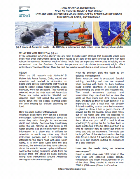
Educators: this worksheet, designed for students ages 11 to 18, accompanies our Snow on Ice blog from early 2019.
Snow on Ice: Seals help scientists explore Thwaites Glacier #6
Calling it seal tagging doesn’t really put the right image in your mind. I had pictured a seal with a small plastic tag attached to its body like you’d see on a cow or pig ear. Seeing it in person was a surprise. Imagine a 600 lb (300 kg) Weddell seal with big dark eyes, a small radio glued to the top of its head, and a black antenna poking up like a single antler. Instead of a gorgeous unicorn, though, you have a huge slug-shaped animal that has no care in the world right now other than to sleep in the sun and eat every once in a while.
A conversation with chief scientist Rob Larter onboard the US icebreaker Nathaniel B. Palmer about the existential guessing game at the bottom of the world, as Jeff Goodell of Rolling Stone magazine reports.
Snow on Ice: Ice above, warm water below #5
As we travel among the Thwaites menagerie of giant icebergs, it’s hard to believe that a thousand feet below the ship sits warm water. This ocean layer, moving slowly toward the base of the ice deep beneath the floating ice shelves has led to faster ice flow, thinning, and more frequent giant calving events at some of the Antarctic outlet glaciers. The water, called Circumpolar Deep Water (or CDW for short), is “relatively warm,” about 3°C (5°F) above seawater freezing temperatures, and it lies below about 250 m (~900 ft) depth in the oceans surrounding Antarctica.
A medical crisis onboard the Nathaniel B. Palmer results in a detour to Rothera Station on the Antarctic Peninsula. Safety of all personnel is paramount on Antarctic missions, as Jeff Goodell of Rolling Stone magazine reports.
Jeff Goodell of the Rolling Stone is onboard the R/V Nathaniel B. Palmer, which is exploring Antarctica to investigate the nightmare scenario of melting ice that could spell disaster for a warming planet. His first dispatch covers the beginning of the 53-day research expedition by sea.
Writing from the US Research Vessel Nathaniel B. Palmer, Rolling Stone's Jeff Goodell confronts the raw power of the sea through the Drake Passage.