Learn more about Thwaites Glacier's size, location, and more
Click here to view our facts sheet as a PDF.
What is Thwaites Glacier?
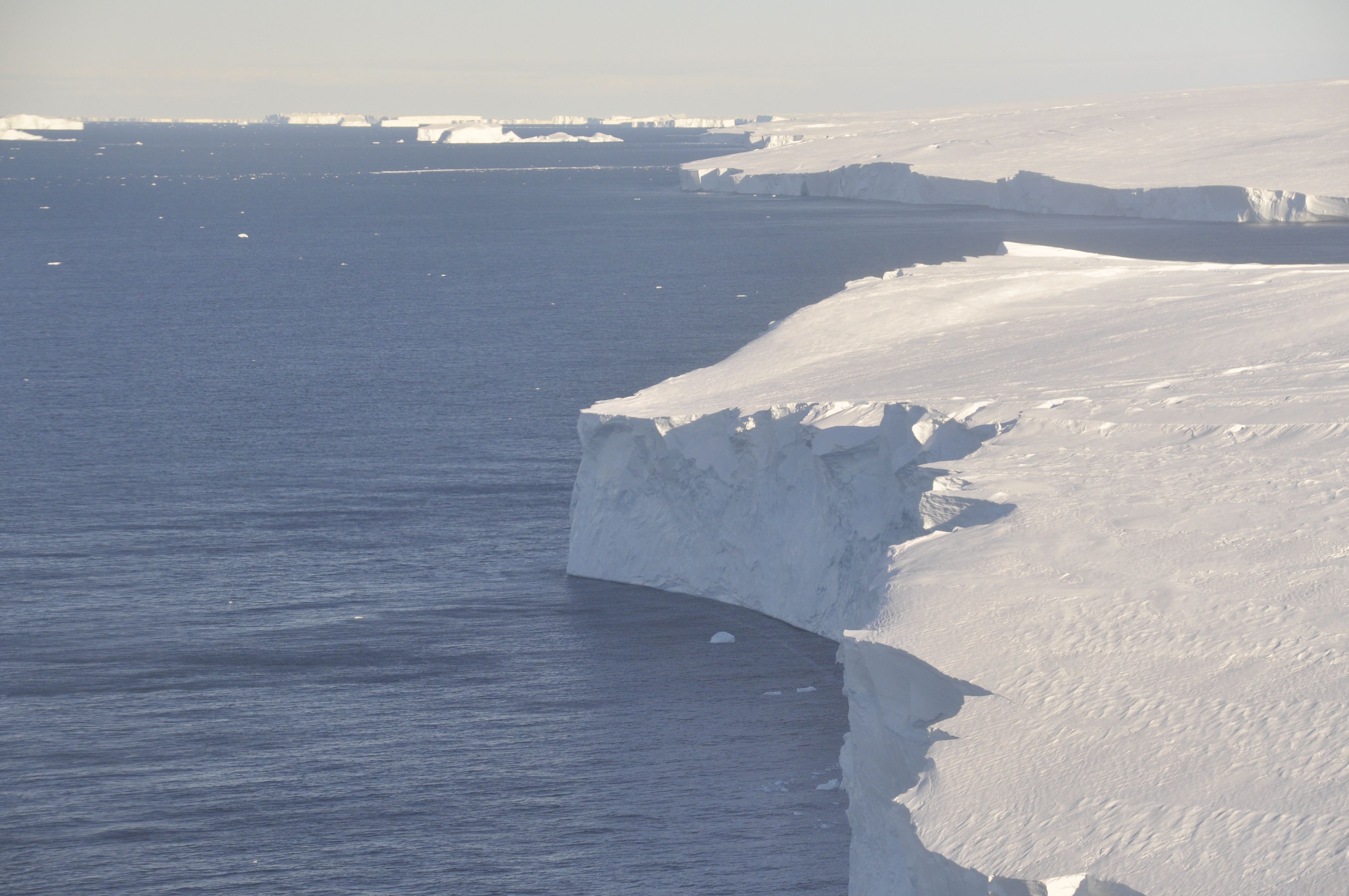
1. Thwaites is the widest glacier on Earth, at ~120 km (~80 miles) wide. Its fastest flowing grounded ice is centred between 50 and 100 km (31 and 62 mi) east of Mount Murphy on the north coast of West Antarctica. (Source: Elevation Map of Antarctica (REMA), Howat et al., 2019, The Cryosphere)
2. Thwaites Glacier Basin measures 74,000 mi² or 192,000 km2 (Source: Rignot 2019, PNAS)
- It is larger than England, Wales and Northern Ireland put together (England, Wales and Northern Ireland have a combined area of 164,000 km2),
- And roughly the size of the island of Britain (Great Britain is 209,000 km2).
- It is larger than US state of Florida (Florida covers an area of 170,000 km2).
3. Thwaites glacier is between 800 and 1200 metres deep at its grounding line (Source: Bedmap2, Fretwell et al., 2013 The Cryosphere; Jordan et al., 2020 The Cryosphere)
Where in Antarctica is Thwaites Glacier?
4. Thwaites Glacier is part of the West Antarctic Ice Sheet (WAIS). The area of WAIS is approximately 3,435,000 km2.
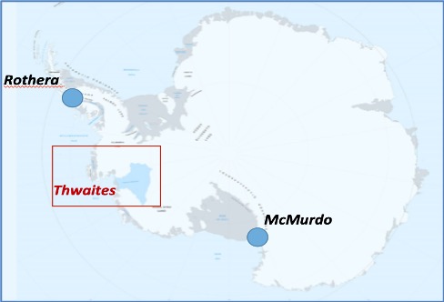
5. Thwaites Glacier is roughly equidistant between the UK’s Rothera Research Station and the US McMurdo Research Station. The Thwaites region of West Antarctica is due south of the western US, 7000 miles away. (Source: Google Earth; Rothera to mid-grounding line of Thwaites Glacier = 1588 km; McMurdo to mid-grounding line of Thwaites Glacier = 2050 km)
Contribution of Thwaites Glacier ice to sea level rise
6. If Thwaites Glacier was to collapse entirely, global sea levels would increase by 65 cm (25 in) (Source: Bedmachine, https://www.nature.com/articles/s41561-019-0510-8#Sec7, gives total volume 483,000 km3; volume above flotation 258,000 km3, and sea level equivalent, 65 cm.)
7. Thwaites Glacier ice loss currently contributes around 4% of all global sea-level rise (assuming 3.5 mm annual sea-level rise) and has the potential to contribute significantly more. (Source: Bedmachine https://www.nature.com/articles/s41561-019-0510-8#Sec7)
8. If Thwaites Glacier continues to accelerate, retreat, and widen at rates consistent with recent changes, it could contribute several cm to sea-level rise by the end of the century. Collapse of the glacier would require a few centuries. (Calculation: 100-km wide front, ~1000 meters thick, 5km/yr, 50 years = ~7 cm)
Ice loss from Thwaites Glacier is significant and increasing
9. Annually Thwaites is losing about 50 billion tons of ice more than it is receiving in snowfall. (Source and calculation: https://data1.geo.tu-dresden.de/ais_gmb/ Over the 14 year period of 2002–2016, Basin AIS21, which is slightly larger than just TG, has lost 748 Gt, equating to 2.07 mm of global sea level compared to a current rate of global sea level rise of 3.2 mma-1=4.6%. 50 billion tonnes assumes 4% of 3.5 mm annual sea-level rise.)
10. Since 2000, the glacier has had a net loss of more than 1000 billion tons of ice. (Source and calculation:) https://data1.geo.tu-dresden.de/ais_gmb/ Over the period 2002–2016 (14 years), Basin AIS21, which is slightly larger than just TG, has lost a total of 748 Gt. Assuming the last 4 years lost ice at the same rate gives a total of 1068 Gt.)
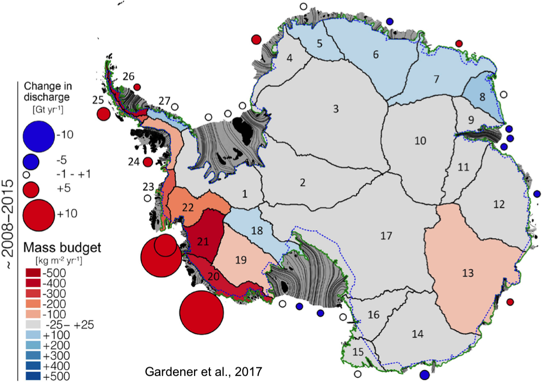
11. The amount of ice loss has doubled over the last 30 years by Thwaites and its neighbouring glaciers.
Thwaites is undergoing change
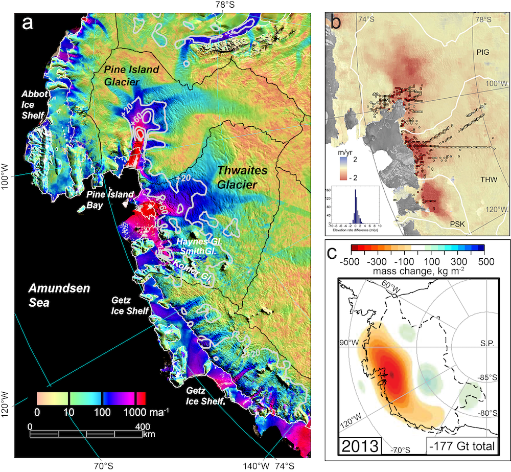
12. Observations show unequivocally that the Thwaites Glacier ice-ocean system is undergoing the largest changes of any ice-ocean system in Antarctica. (Sources: Mouginot et al., 2014, Geophysical Res. Letters; Paolo et al., 2015 Science; Scambos et al. 2017, Global & Planetary Change.)
13. Ice surface speeds exceed 2 km annually (1.2 miles annually) near its grounding line. (Sources: Mouginot et al., 2019, Geophys. Res. Lett., Gardner et al., 2018, The Cryosphere (using Landsat))
14. NASA discovered an underwater cavity underneath the glacier, with an area two-thirds the size of Manhattan in January 2019. The cavity formed mostly in the previous three years and is nearly a thousand feet tall, likely speeding up the glacier's decay. (Source: MIllilo et al., 2019, Science)
15. Warming of the atmosphere and ocean and their interaction with the glacier are driving the change. (Source: Scambos et al. 2017, Global & Planetary Change and references therein, Hillenbrand et al., 2017, Nature)
Thwaites Glacier first appears on our maps
16. The first identification of Thwaites Glacier was in January 1947 through the mapping of its ice tongue by the US Navy during the airborne photographic surveys of Operation High Jump. The first sighting of the coastline in this area of Antarctica was in 1940, as part of the third Byrd expedition. The glacier itself was mapped more thoroughly in 1959-66. (Source: Geographic Names of the Antarctic, US Board on Geographic Names, 1980.)
17. Thwaites Glacier was named after Fredrik T. Thwaites (1883–1961), a glacial geologist, geomorphologist and professor emeritus at the University of Wisconsin–Madison. Professor Thwaites never actually visited the glacier.
International Thwaites Glacier Collaboration (ITGC)
18. ITGC consists of eight science projects, six are field-work oriented, and two are focused on modeling of glacier processes and its recent and future evolution. (Source: https://thwaitesglacier.org/)
19. ITGC is the largest joint US-UK programme of field science yet undertaken in the Antarctic, in terms of numbers of separate deployments of scientists to field and marine sites.
- Over 100 scientists and support staff are involved in the ITGC in the 2019-2020 research season.
- The 5-year collaboration is costing an estimated $50M.
More about the West Antarctic Ice Sheet (WAIS)
20. WAIS is large! 14 times the size of Great Britain, about the size of India, nearly twice the area of Alaska, or more than 100 times the area of Belgium.
21. If the WAIS collapsed and melted in its entirety, global sea levels would rise by 3.3 metres; however, this process would require centuries to millennia. (Source: Bamber et al., 10.1126/science.1169335)