Newly discovered deep seabed channels beneath Thwaites Glacier in West Antarctica may be the pathway for warm ocean water to melt the underside of the ice. Data from two research missions, using aircraft and ship, are helping scientists to understand the contribution this huge and remote glacier is likely to make to future global sea level rise.
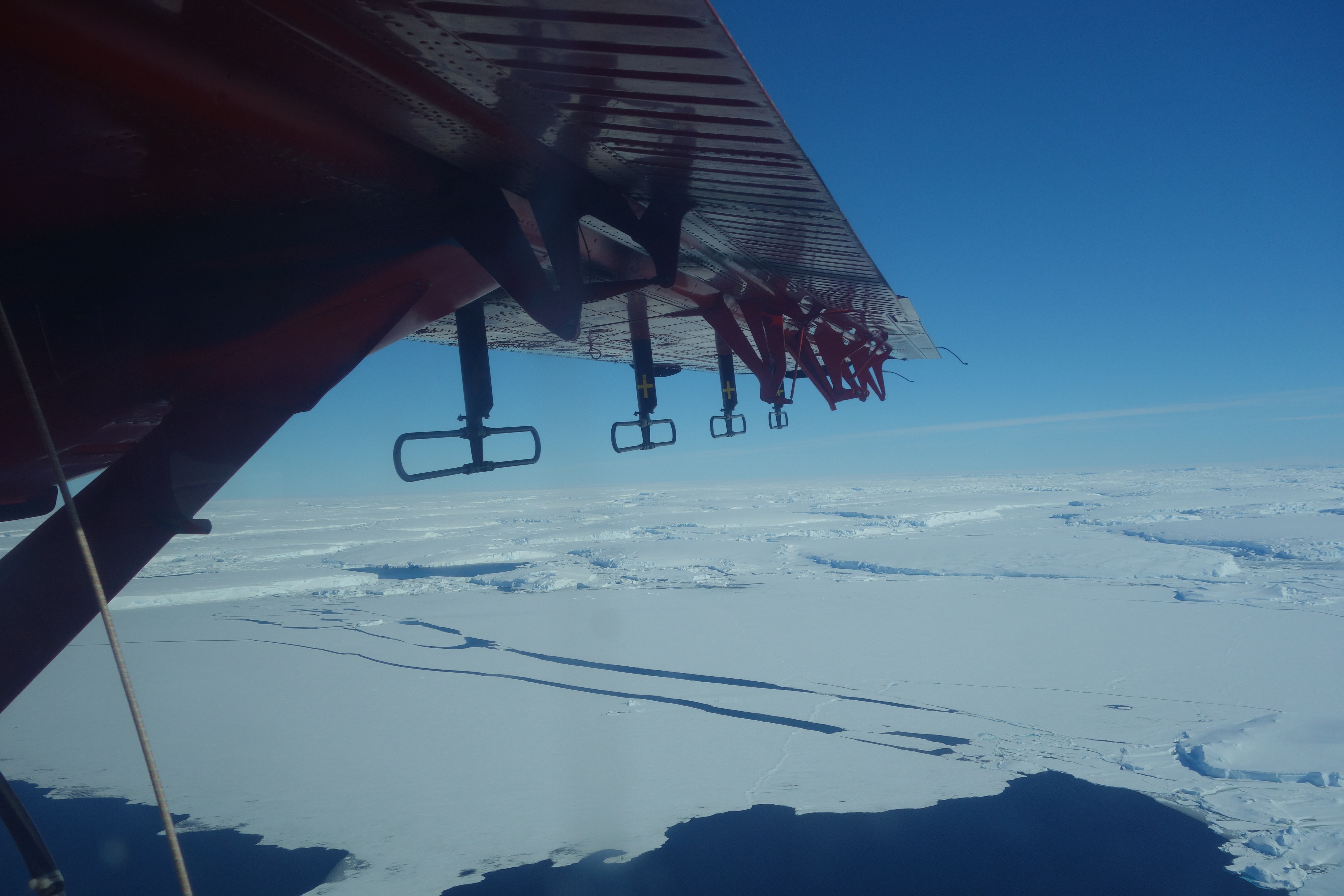
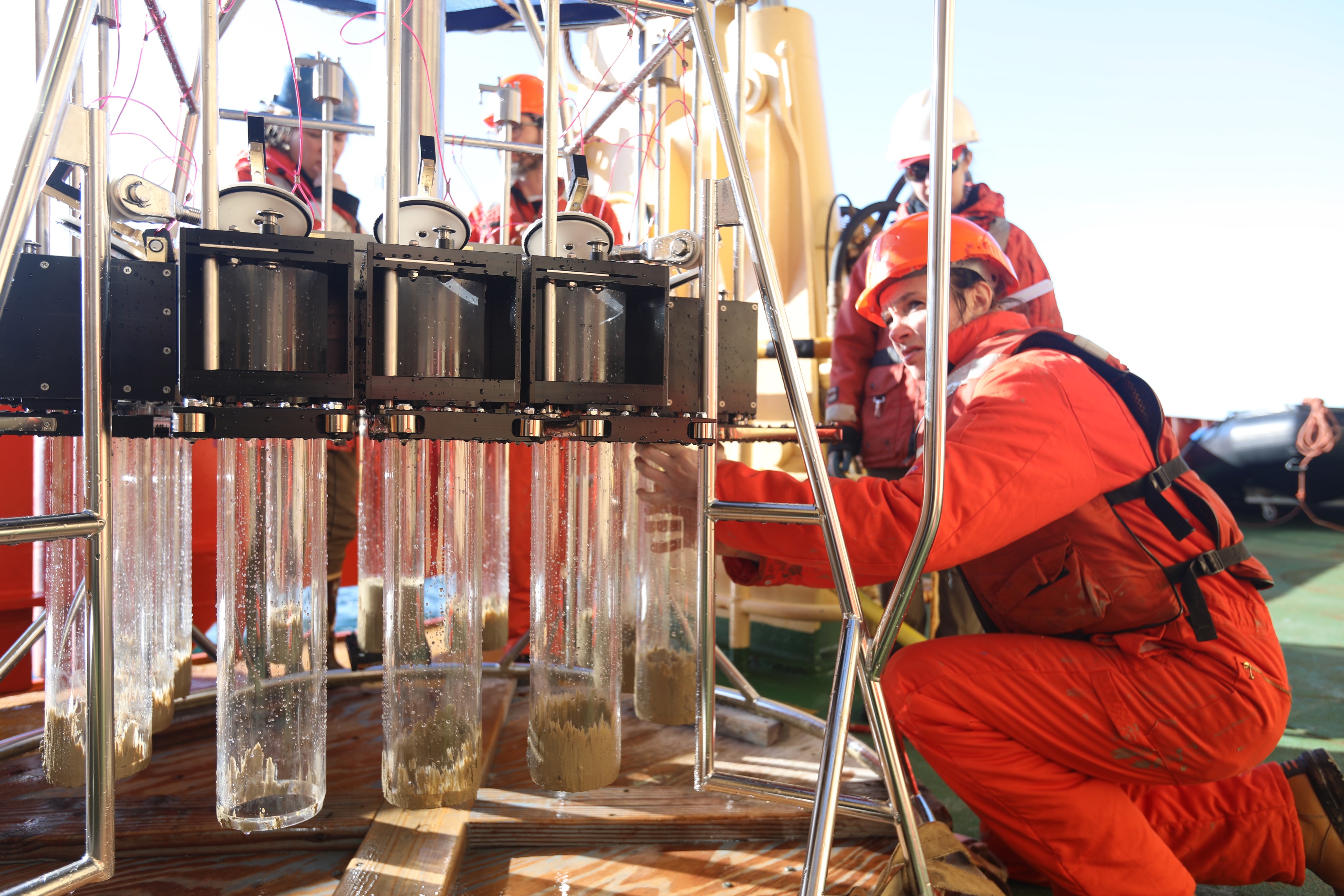
Researchers from UK and US International Thwaites Glacier Collaboration (ITGC), collected data from the glacier and adjoining Dotson and Crosson ice shelves during January-March 2019. While one team collected airborne data flying over the glacier and ice shelf in a British Antarctic Survey Twin Otter aircraft, the other mapped the sea floor at the ice front from the US Antarctic Program icebreaker RV Nathaniel B Palmer.
Publishing this month (9 September) in the journal The Cryosphere, the two research papers describe the discovery. Thwaites Glacier covers 192,000 square kilometres (74,000 square miles) - the size of Great Britain or the US state of Florida – and is particularly susceptible to climate and ocean changes.
Over the past 30 years, the overall rate of ice loss from Thwaites and its neighbouring glaciers has increased more than 5-fold. Already, ice draining from Thwaites into the Amundsen Sea accounts for about four percent of global sea-level rise. A run-away collapse of the glacier could lead to a significant increase in sea levels of around 65 cm (25 inches) and scientists want to find out how quickly this could happen.
Lead author Dr Tom Jordan, an aero-geophysicist at British Antarctic Survey (BAS), who led the airborne survey, says:
“It was fantastic to be able to map the channels and cavity system hidden beneath the ice shelf; they are deeper than expected – some are more than 800 metres deep. They form the critical link between the ocean and the glacier.
“The offshore channels, along with the adjacent cavity system, are very likely to be the route by which warm ocean water passes underneath the ice shelf up to the grounding line, where the ice meets the bed.”
Dave Porter at LDEO Columbia University, who flew over Thwaites Glacier for the airborne survey, says:
“Flying over the recently-collapsed ice tongue and being able to see first-hand the changes occurring at Thwaites Glacier was both awe inspiring and disconcerting, but also gratifying to know the airborne data we were collecting would help reveal the hidden structures below.”
Exceptional sea-ice break up in early 2019 enabled the team on the RV Nathaniel B Palmer to survey over 2000 square kilometres of sea floor at the glacier’s ice front. The area surveyed had previously been hidden beneath part of the floating ice shelf extending from Thwaites Glacier, which broke off in 2002, and in most subsequent years the area was inaccessible due to thick sea-ice cover. The team’s findings reveal the sea floor is generally deeper and has more deep channels leading towards the grounding line under the ice shelf than was previously thought.
Lead author, Dr Kelly Hogan, is a marine geophysicist at BAS. She was part of the team surveying the seabed. She says:
“We found the coastal sea floor, which is incredibly rugged, is a really good analogue for the bed beneath the present-day Thwaites Glacier both in terms of its shape and rock type. By examining retreat patterns over this sea-floor terrain we will be able to help numerical modellers and glaciologists in their quest to predict future retreat.
“This research has filled a critical data gap. Together the new coastal sea floor maps and the cavity maps track the deep channels for over 100 km to where the glacier sits on the bed. For the first time we have a clear view of the pathways along which warm water can reach the underside of the glacier, causing it to melt and contribute to global sea-level rise.”
New gravity-derived bathymetry for the Thwaites, Crosson, and Dotson ice shelves revealing two ice shelf populations by Jordan, T. A., Porter, D., Tinto, K., Millan, R., Muto, A., Hogan, K., Larter, R. D., Graham, A. G. C., and Pade, J. D. is published in The Cryosphere, 14, 2869–2882, https://doi.org/10.5194/tc-14-2869-2020, 2020.
Revealing the former bed of Thwaites Glacier using sea-floor bathymetry: implications for warm-water routing and bed controls on ice flow and buttressing by Hogan, K. A., Larter, R. D., Graham, A. G. C., Arthern, R., Kirkham, J. D., Totten Minzoni, R., Jordan, T. A., Clark, R., Fitzgerald, V., Wåhlin, A. K., Anderson, J. B., Hillenbrand, C.-D., Nitsche, F. O., Simkins, L., Smith, J. A., Gohl, K., Arndt, J. E., Hong, J., and Wellner, J. is published in The Cryosphere, 14, 2883–2908, https://doi.org/10.5194/tc-14-2883-2020, 2020.
Ends
Released 00:01 on Wednesday 9 September UK BST / 17:01 on Tuesday 8 September US MDT
Issued by the British Antarctic Survey Press Office on behalf of the International Thwaites Glacier Collaboration (ITGC).
Please contact Senior Communications Manager: Athena Dinar email: amdi@bas.ac.uk, tel: +44 (0) 7909 008516
Corporate and Internal Communications Manager: Livia Oldland email: livand@bas.ac.uk. Tel: +44 (0) 7850 541910
Images and video of researchers working on the ship and from the air are available from the Press Office as above.
ITGC is a five-year, $50 million joint U.S. and U.K. mission to learn more about Thwaites Glacier, its past, and what the future may hold. Significant contributions to the research are also coming from Sweden, Germany, and South Korea. The ultimate goal of the project is to predict how much Thwaites will contribute to global sea-level rise, and how soon a transition to more rapid ice retreat might occur. ITGC is funded by the U.S. National Science Foundation (NSF) and U.K. Natural Environment Research Council (NERC). www.thwaitesglacier.org
Ice shelf – is a large floating platform of ice that forms where a glacier or ice sheet flows down to a coastline and onto the ocean surface. Ice shelves are only found in Antarctica, Greenland, Canada, and the Russian Arctic.
Ice sheet - also known as a continental glacier, is a mass of glacial ice that covers surrounding terrain and is greater than 50,000 km2 (19,000 sq mi).
Glacier - is a huge mass of ice that moves slowly over land. The term “glacier” comes from the French word glace (glah-SAY), which means ice. Glaciers are often called “rivers of ice.”
The Natural Environment Research Council (NERC) is the UK's main agency for funding and managing research, training and knowledge exchange in the environmental sciences. Our work covers the full range of atmospheric, Earth, biological, terrestrial and aquatic science, from the deep oceans to the upper atmosphere and from the poles to the equator. We coordinate some of the world's most exciting research projects, tackling major issues such as climate change, environmental influences on human health, the genetic make-up of life on Earth, and much more. NERC is part of UK Research and Innovation, a non-departmental public body funded by a grant-in-aid from the UK government. Find out more at nerc.ukri.org.
The U.S. National Science Foundation (NSF) was established in 1950 by the U.S. Congress "to promote the progress of science; to advance the national health, prosperity and welfare; to secure the national defense; and for other purposes." NSF is vital because its supports basic research to create knowledge that transforms the future. With an annual budget of $7.8 billion (fiscal year 2018), NSF funds discovery, learning, innovation and research infrastructure to boost U.S. leadership in all aspects of science, technology, engineering and mathematics (STEM) research and education. In contrast, other federal agencies support research focused on specific missions, such as health, energy or defense.
Through its Office of Polar Programs, the U.S. National Science Foundation manages the United States Antarctic Program (USAP). Under a Presidential Mandate, the Program coordinates all U.S. research on the Southernmost Continent, funds Antarctic research carried out by university researchers nationwide, operates three year-round Antarctic research stations and two research vessels and provides or coordinates all of the logistical support required to make the science possible.
British Antarctic Survey (BAS), an institute of the Natural Environment Research Council (NERC), delivers and enables world-leading interdisciplinary research in the Polar Regions. Its skilled science and support staff based in Cambridge, Antarctica and the Arctic, work together to deliver research that uses the Polar Regions to advance our understanding of Earth as a sustainable planet. Through its extensive logistic capability and know how BAS facilitates access for the British and international science community to the UK polar research operation. Numerous national and international collaborations, combined with an excellent infrastructure help sustain a world leading position for the UK in Antarctic affairs. For more information visit www.bas.ac.uk @basnews