The sheer scale of the glacier captivated Ted Scambos as he looked on from his plane window, thousands of feet above the ice. The widest glacier in the world, the frozen white Antarctic landscape of Thwaites seemed to stretch on forever—an area as large as Florida, and a mile or more thick. But all of it was at risk, already thinning rapidly and flowing faster into the ocean as a result of climate change.
Scambos is a co-investigator of the Thwaites-Amundsen Regional Survey and Network (TARSAN) project for the International Thwaites Glacier Collaboration (ITGC), an effort to understand the processes that are altering the glacier and better predict how its deterioration could contribute to sea level rise. In this joint undertaking between the United Kingdom and the United States, Scambos also serves as the scientific coordinator representing the U.S. During the second field season of the five-year endeavor, Scambos could feel the threat of climate change beneath his feet as he camped on the floating ice.
“Being out there, it just changes your perspective on why you're doing what you're doing and the actual consequences that are going to result from all of this,” said Scambos.
Getting to the bottom of Thwaites’ decline—literally
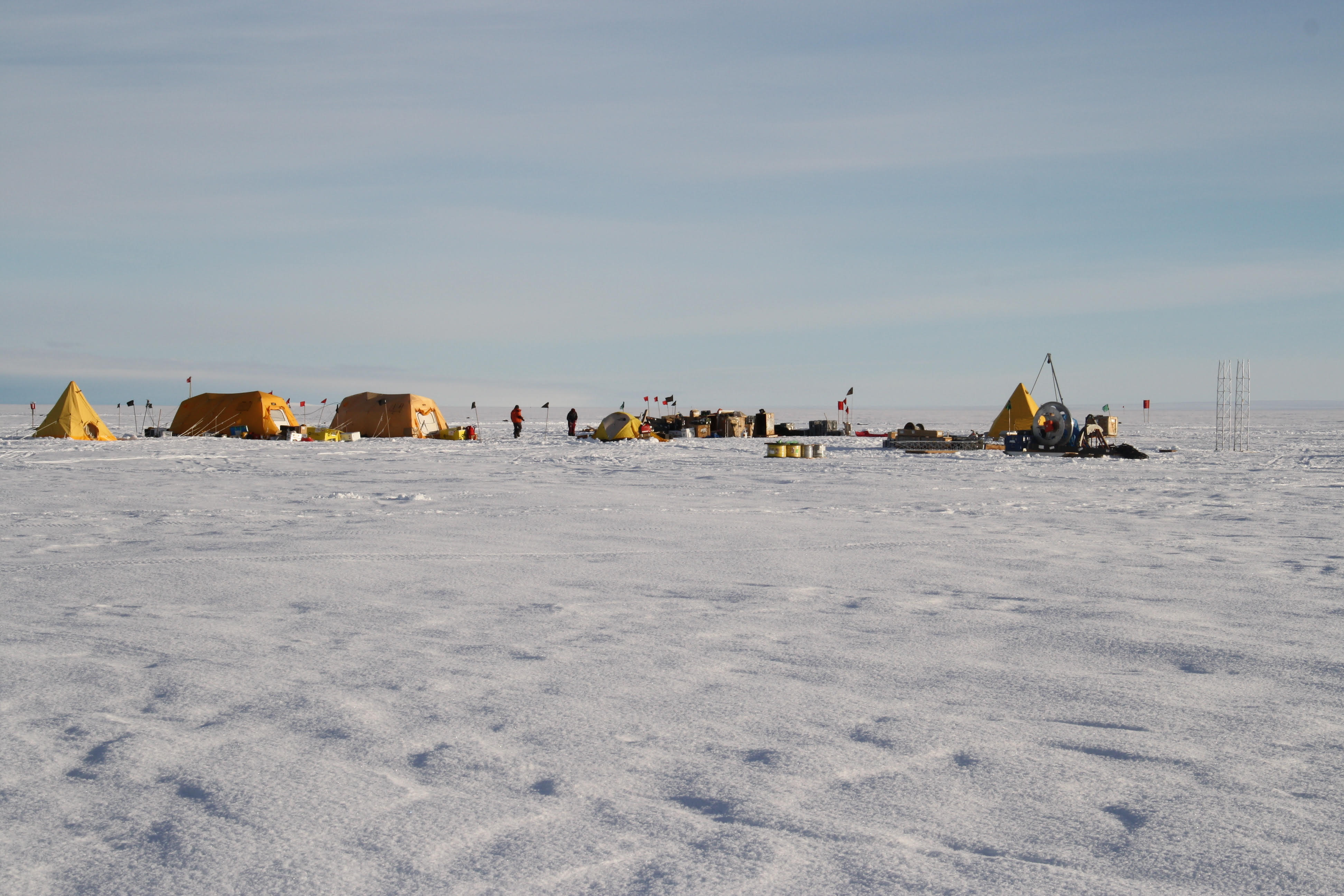
The TARSAN project is investigating atmospheric and oceanic conditions on two ice shelves on the coast near Thwaites Glacier. Ice shelves are extensions of the glacier that float over the ocean, hundreds of feet thick. They contribute to the forces holding the glacier back, slowing its flow—but as they thin and decay, the glaciers feeding them accelerate.
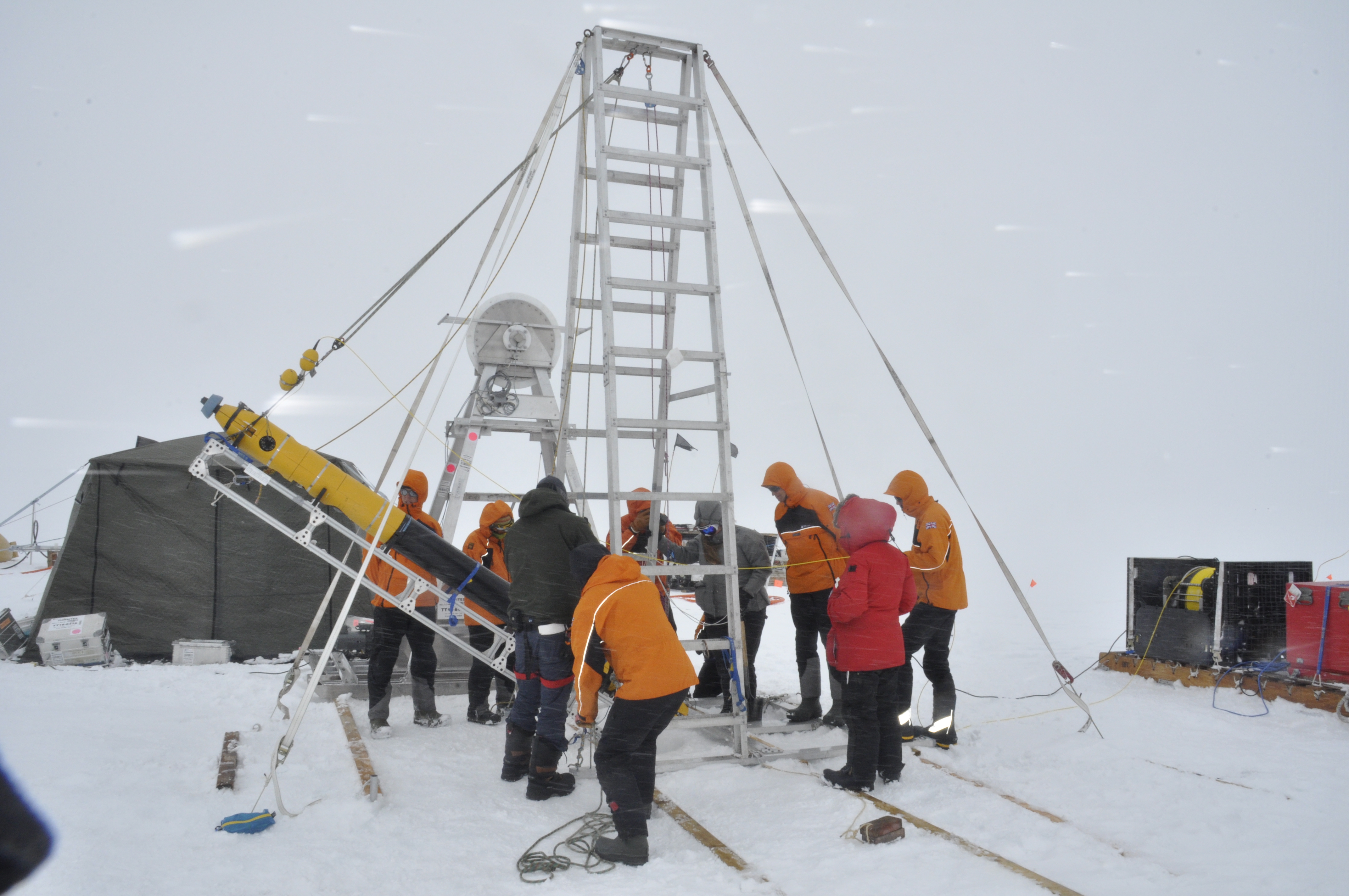
Scambos engaged the help of a team of undergraduate engineering students from the University of Colorado Boulder, who built three automated instrument stations to collect data on the glacier for the next few years. The students also helped develop a pressure vessel that would give scientists the chance to not only gather data on the oceanic conditions below, but see them with their own eyes.
“The students did a fantastic job on the three stations, which were loaded with sensors that included just about everything you could want to study the conditions around the glacier. But the thing that I was most excited about was this pressure vessel,” Scambos said.
It was a tiny GoPro, housed inside the pressure vessel, that was the source of Scambos’ enthusiasm. Along with it, the TARSAN team lowered several instruments for measuring oceanic conditions on a journey down an 300-meter (1000-foot) long borehole, through the bottom of the glacier and into the watery depths below. As it advanced, the camera captured the changing layers of the borehole from the rough, twinkling icicles at the top to the older, more compressed ice. The walls became clear and transparent, like windows into the glacier, with the light from the GoPro extending out into what otherwise would have been utter darkness.
Once the vessel plunged into the salty waters of the Amundsen Sea, it still had a ways to go before reaching the seafloor. Though it was mostly a long lonely trek, there were a few visitors, including a bright orange squid.
The presence of life beneath the glacier fits in with some of the preliminary findings from this field season: there is warm water circulating under Thwaites.
“The eyes of the world are on us”
TARSAN is one of the ITGC’s eight research projects that study the entire glacier, tackling the question of the glacier's deterioration from a variety of different angles and scientific fields. The task of coordinating a collaborative effort of this scale is one that ITGC scientific coordinator David Vaughan finds both daunting and exciting.
“This project has come at a time when the eyes of the world are on us and people really want answers to these scientific questions,” Vaughan said, who works alongside Scambos as the United Kingdom’s representative.
Vaughan traveled to Thwaites with a team of journalists from the BBC to visit the base camp of another research project, called Melting at Thwaites grounding zone and its control on sea level, or MELT for short. MELT's scientists are investigating how warm ocean waters affect the glacier at its grounding line. This area is a crucial place of transition for glaciers, marking where the base of the ice sheet meets warm water and begins to float, becoming an ice shelf. Like TARSAN, MELT also had a hand in giving scientists a never-before-seen look at Thwaites with the help of an autonomous vehicle called Icefin.
The black and bright yellow robot is no small fry: Icefin weighs 130 kilograms (286 pounds) and is 3.5 meters (11.5 feet) long. Outfitted with both a camera and sensors to measure water parameters like salinity, temperature and turbidity, Icefin took a dive down to the grounding line. The measurements that it captured from this trip will lend help to modeling and predicting the future of Thwaites, while the video footage gave researchers a new, human perspective of the glacier's deterioration. Video images showed a scalloped pattern on the underside of the ice, a sign of turbulence in the warm water as it melts the bottom of the ice.
Though these signs were not unexpected due to previous measurements and modeling, to see it first hand made the evidence even stronger to Vaughan.
“It’s actually a revelation in many ways, a complete revelation,” said Vaughan. “Even if we suspected that some things happening underwater were as they were.”
Investigating the influence of both land and sea
Other projects that completed field work this season include Geological History Constraints (GHC), Thwaites Interdisciplinary Margin Evolution (TIME) and Thwaites Offshore Research (THOR).
GHC studies the history of the glacier by analyzing samples from the bedrock below the ice at two locations on opposite sides of a large embayment where the largest glaciers are impacted by deep warm water flow: Mt. Murphy and the Hudson Mountains. By looking at the radioactive signatures of these samples, scientists can determine retreats and advances in the ice sheet from the last several thousand years. The team at Mt. Murphy collected four bedrock samples by drilling through the surface, while the Hudson Mountains team used radar to identify good drill sites for the next research season.
Shear margins on glaciers are where the fast moving ice flowing out of the glacier meets a boundary of more stationary ice. At these margins the ice rapidly moving downstream in the glacier can eat into the stationary ice, grabbing it and carrying it along on its outbound journey. It’s a central process to the melting of Thwaites that has larger implications for the stability of the West Antarctic Ice Sheet as a whole. TIME investigated shearing activity on the sides of the glacier with radar, in preparation for a bigger group that will be conducting research next year.
Conducted on board the U.S. Research Vessel Nathaniel B. Palmer, the field season for THOR began in late January, as the team needed to wait for the sea ice on the ocean to retreat before embarking on their research cruise. Data that they collected through March will give insight into ocean conditions further away from Thwaites that could be contributing to its deformation.
Though the central goal of ITGC is to determine the time frame for and consequences of Thwaites’ collapse, the wider mission is to produce research that will benefit scientists studying ice sheet behavior in other locations as well.
“[I hope] that some of the data that we have and the insight into key processes will not just feed into our own modeling projects, but will actually reach into the next generation of projections from the wider ice sheet modeling community,” said Vaughan.
By Julia Medeiros, University of Colorado Boulder